
Santa Cruz, CA 95060
$979,000


Bed
0
Bath
0
Living Space
N/A SqFt
Year Built
N/A
Lot Size
5,000 SqFt
Days
118
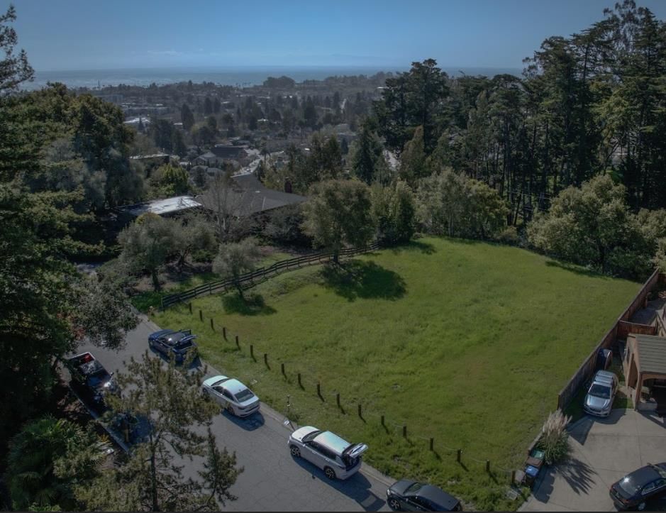
The Circles are the heartbeat of Westside Santa Cruz. Unique concentric streets radiate out from Errett Circle like a bullseye creating an uncommon and beautifully laid plan that has shaped the Westside's identity for almost 140 years. For the first time the center circle has opened up to residential development. The community of homes planned is designed for gathering.The Circles sit between Mission St & W Cliff Dr. With a Walk Score of 82 and Bike Score of 100~you wont need to drive to access the very best~located just a few blocks awaythe Pacific Ocean & Monterey Bay, Lighthouse Field & Steamer Lane, theWharf & Boardwalk, Mitchells Cove w/incredible sunset views over world class surf breaks and Natural Bridges State Beach. Positioned at 10,11 & 12 on the clock, these are sought after lots that face West Cliff Dr w/ocean views from a 2nd story perch. 5K sf lots are fully cleared and ready to submit plans for permits. Theres a community centerpiece/gathering space that features a grassy lawn, fire pits, a bocce court, raised flower beds, picnic areas & community gardens. This is a rare chance to design-build your dream home and to get in on the ground floor and seize an early advantage to nurture a unique community in one of the most coveted and fiercely loved neighborhoods.
Listing provided courtesy ofDaniel Alvarez License 01237892 David Lyng Real Estate
Data provided by MLSListings Inc.
- Bay View Elementary School (Elementary) - GreatSchools rating 8/10 - Mission Hill Middle School (Middle) - GreatSchools rating 9/10 - Santa Cruz High School (High) - GreatSchools rating 10/10 School District: SantaCruzCityElementary
Within a 1-2 mile radius of 111-09 Errett Circle, Santa Cruz, CA, 95060, several parks and recreational areas are available. These include Depot Park, which offers a playground, picnic area, and bike park; DeLaveaga Park, featuring picnic areas, trails, and a golf course; and Garfield Park, with a playground, basketball court, and picnic tables. Additionally, Beach Flats Park provides a playground and picnic tables, while Chestnut Park offers a playground and picnic tables.
The neighborhood is known as "The Circles," characterized by its unique concentric street layout that has defined the Westside's identity for nearly 140 years. This area is undergoing residential development with a focus on creating a community designed for gathering. It is situated between Mission Street and West Cliff Drive, offering proximity to the Pacific Ocean, Monterey Bay, Lighthouse Field, Steamer Lane, the Wharf, and the Boardwalk.
This area is considered "Very Walkable" with a Walk Score of 83/100 and has "Some Transit" with a Transit Score of 35/100. It is also a "Biker's Paradise" with a Bike Score of 100/100. Public transit options include 6 nearby bus routes.
This neighborhood information is AI-generated based on the property address and publicly available data. Please verify important information independently. Do not rely solely on this information for property decisions. RoostHaven makes no warranties and assumes no liability for the accuracy or completeness of AI-generated information. School boundaries, ratings, and local amenities may change over time.
- Bay View Elementary School (Elementary) - GreatSchools rating 8/10 - Mission Hill Middle School (Middle) - GreatSchools rating 9/10 - Santa Cruz High School (High) - GreatSchools rating 10/10 School District: SantaCruzCityElementary
Within a 1-2 mile radius of 111-09 Errett Circle, Santa Cruz, CA, 95060, several parks and recreational areas are available. These include Depot Park, which offers a playground, picnic area, and bike park; DeLaveaga Park, featuring picnic areas, trails, and a golf course; and Garfield Park, with a playground, basketball court, and picnic tables. Additionally, Beach Flats Park provides a playground and picnic tables, while Chestnut Park offers a playground and picnic tables.
The neighborhood is known as "The Circles," characterized by its unique concentric street layout that has defined the Westside's identity for nearly 140 years. This area is undergoing residential development with a focus on creating a community designed for gathering. It is situated between Mission Street and West Cliff Drive, offering proximity to the Pacific Ocean, Monterey Bay, Lighthouse Field, Steamer Lane, the Wharf, and the Boardwalk.
This area is considered "Very Walkable" with a Walk Score of 83/100 and has "Some Transit" with a Transit Score of 35/100. It is also a "Biker's Paradise" with a Bike Score of 100/100. Public transit options include 6 nearby bus routes.
This neighborhood information is AI-generated based on the property address and publicly available data. Please verify important information independently. Do not rely solely on this information for property decisions. RoostHaven makes no warranties and assumes no liability for the accuracy or completeness of AI-generated information. School boundaries, ratings, and local amenities may change over time.